Do you possess the inner-urgings to "take an ownership stake" in the betterment of your community? Have you observed poor or even risky boating techniques that endanger the physical well-being of boaters, swimmers, and/or children? If so, and though you may be unaware of it, the Lake Gaston Water Safety Council may be just the organization to provide you with the opportunity to do good things for your lake community while developing friendships with many other like-minded individuals who welcome the opportunity to make a difference. Consider joining us.
Your membership helps to support the many water safety activities carried on by the Lake Gaston Water Safety Council. Memberships are $5.00 per person - $10.00 per family $10.00 per Business. Our Business members have the option of having their website link posted on our member page. These annual dues help to support our Water Safety Trailer, Get Home Safely and the Children's PFD (Life Jacket) loaner programs along with many other activities in the lake area. If you would like more information on becoming a member please feel free to Contact Us. We value your privacy and will not share any personal information you provide.
To become a member of the LGWSC, or renew your existing membership, simply complete the on-line membership category application form below. Please select whether you are paying by credit card on-line, or submitting payment by US Mail. Once you submit the FORM below, you will be redirected to another page with complete payment instructions.
If you prefer to print and complete the membership form instead of completing on-line, click below for a user-friendly copy, and follow instructions within.
Unless otherwise noted, seven meetings are held the last Wednesday of each month during the boating season. The evening customarily commences with a "Social Half Hour" at 5:30, a "Dutch-treat" Dinner at 6 PM, followed by the Membership Meeting. Meetings are held at the Kennon House Restaurant, 7001 Gasburg Rd. (Rt. 626, ½ mile east of Pea Hill Creek), Gasburg, VA 23857; Phone: (434) 577-2680. The public is invited and welcome to attend!
It is customary to hold a Pig Pickin' for our September meeting.
There are no meetings from October to February.
LGWSC business meetings are open to the public. For more information, contact President Lewis Mustian at lmustian48@This email address is being protected from spambots. You need JavaScript enabled to view it..
In this article, I am only going to focus on the markers on Lake Gaston. In my next article I will focus on the ‘lateral markers,’ or what we call ATON’s. (Aids TO Navigation).
Our lake runs ‘west’ to ‘east’ and is about 34 miles long. Our shore line is over 350 miles. We have many ‘creeks’ and the varying depths and obstructions make it important to know how to safely navigate.
First, a little basic navigation. There are two types of ‘markers’ on our lake. That is, markers found on both the ‘main lake’ (the river) and those up in the ‘creeks’. These are placed to assist boaters in navigating our lake. These buoys are fixed to the lake bottom by a weight and tethered by a line or chain. On our lake – these are called ‘Non-Lateral Markers’. These are navigation aids that give
information other than the edges of safe water areas. The most common are regulatory markers that are white and use orange markings and black lettering. These are found on lakes and rivers and are used to:
1. Give direction and information
2. Warn of hazards and obstructions
3. Mark controlled areas
4. Mark off-limits area.
Let’ discuss each
1. ‘Information’: These have squares on them and provide information such as places to find food, supplies, and repairs; and they give directions, distances, and other nonregulatory information.
2. ‘Danger area’: These have diamonds on them and warn of dangers such as rocks, shoals, construction, dams, or stumps. Always proceed with caution and keep a safe distance. Never assume that every hazard will be marked by a buoy !
3. ‘Controlled Areas’: These have circles on them and indicate a controlled area such as no wake, idle speed, speed limit, or ski zone.
4. ‘Exclusion Area’: These have crossed diamonds on them and indicate areas off-limits to all vessels such as swimming areas, dams, and spillways.
Several years ago Dominion Power installed ‘mile markers’. The first mile marker is one mile from the Gaston Dam, then two, three, four………..etc. These have been a tremendous aid to our boaters. It has also been a great assist to those of us in the Coast Guard Auxiliary, Coast Guard, and both VA and NC Wildlife in helping find boaters in distress. If you concentrate on each of these – when you break down – you can give us your last position. We can then find you with much more ease. Remember the size of our lake !
Now, here I would like to point out something very important! These buoys are very expensive – and require a great deal of hard work insuring that each of these buoys are in their proper location. We’ve had situations in which some boaters deliberately damage these buoys. Some don’t like the lights on the top of some of the buoys. These are obviously there to assist the night time boaters. Whenever damage is done to these buoys – we all pay! Our tax dollars at work folks. Let’s don’t waste our tax dollars. Be courteous and stay away from the buoys. Dominion Power owns the mile markers: Both VA and NC own many others in their state: And the ‘private’ buoys are owned by individual owner(s).
Stay away: Let’s talk about that. You NEVER tie up to a buoy. And, if you are at planing speed – stay at least 50 feet away from these buoys. Your bow waves can move them off position. If these are danger buoys – they can stray away from huge rocks in the lake which are really hard on the bottom of your boat. If any of you have ever had to pay to have fiberglass repaired – you will appreciate my remarks. Repairing fiberglass is expensive.
Learn more about all aspects of being a better boater by coming to the US Coast Guard Auxiliary’s next boating safety class.
Our boating safety classes are taught the third Saturday of each month from March to September. For information on enrolling in this class – please call 252 535-3335
Part 2
Now, let's talk about the markers on the Inter Coastal. These buoys and markers are the "traffic signals" that guide boat operators safely along some waterways. The also identify dangerous or restricted areas and give directions and information. As a recreational boat operator you will need to know the lateral navigation markers and non-lateral markers of the U.S. Aids to Navigation Systems. If you never do any boating on the inter-coastal – you'll never remember what I'm going to address in the following paragraphs. However, if you do decide to go boating on the inter-coastal – be sure to brush up on your navigation 'buoys'. It can get real hairy out there with markers that you are unfamiliar with.
Let's review a few
Colors and Numbers mean the same thing regardless of what kind of buoy or marker on which they appear.
Red Colors (Red Lights & Even Numbers) - These indicate the right side of the 'channel' as a boater enters from the open sea or heads upstream. Numbers will usually increase consecutively as you 'return from the open sea' or head upstream.
Green Colors (Green Lights & Odd Numbers) - These indicate the left side of the channel as a boater enters from the open sea or heads upstream. Numbers will usually increase consecutively as you return from the open sea or head upstream.
Let me veer off my train of thought for just a moment. You have heard the expression "Red ... Right ... Returning". That means keep the 'red' buoys on the 'right' side of your boat when 'returning' from the sea.
Now I'm going to confuse you a bit. You run into...
Red & Green Horizontal Stripes - Oops... it's 'red... right... returning' – but the buoys have both colors!
These are placed at the junction of two channels to indicate the preferred (primary) channel when a channel splits. In other words, you have come to a 'split in the road'. If green is on the top, the 'preferred' channel is to the right. If red is on top, the 'preferred' channel is to the left. The light color matches the top stripe. These are also sometimes referred to as 'junction buoys".
Remember – you might be navigating your vessel way up a river to get home. Unlike Lake Gaston – you can go several hundred miles.
Let's talk about 'Shapes'
Nun buoys: These cone-shaped buoys are always marked with red markings and even numbers. They mark the right side of the channel as a boater enters from the open sea or heads upstream.
Can buoys: These cylindrical-shaped buoys are always marked with green markings and odd numbers. They mark the left side of the channel as a boater enters from the open sea or heads upstream. (I'm always reminded of a can of string beans…and when I was young, they tasted 'odd').
Other kinds of buoys and markers
Lighted buoys: These buoys use the lateral marker colors and numbers discussed above. In addition, they have a matching colored light.
Day beacons: These are permanently placed signs on land or are attached to structures such as posts in the water. Common day beacons are red triangles (equivalent to nuns) and green squares (equivalent to cans). These may also be lighted.)
The Intracoastal Waterway (ICW) is a chain of local channels linked together to provide an inland passage along the Atlantic and Gulf of Mexico coasts. Channels that are part of the ICW are identified by yellow symbols on channel buoys and markers. Buoys and markers that bear these yellow symbols are serving a dual purpose.
If you are following the Intracoastal Waterway in a clockwise direction starting from New Jersey and heading to Brownsville, Texas, then:
Any marker displaying a yellow triangle should be passed by keeping it on the starboard (right) side of the boat. Any marker displaying a yellow square should be passed by keeping it on the port (left side) of the boat. This is true regardless of the shape or color of the channel marker or buoy on which the ICW symbols are displayed. That is, when you are following the Intracoastal Waterway, the yellow triangles and squares should be used as guides, rather than the colors and shapes of the Lateral System markers on which they appear.
Western Rivers System
This system of markers is used on the Mississippi River and its tributaries. The major difference from the U.S. Aids to Navigation System lateral markers discussed previously is that navigation markers on the Western Rivers System are not numbered. Numbers displayed below day beacons along this system are not associated with the right or left side of the channel; these numbers indicate distance from the river mouth (except on the Ohio River where the numbers indicate distance from the headwaters).
OK Folks ... with the last two 'lessons' in navigating – are you ready to take an extended trip to South America? I doubt it. I hope you have learned enough with these last two articles to know how much you 'don't know'. The point I hope you came away with is that you need to take a good navigation course to learn all the 'ins ... and outs' ... of navigation. Hopefully this just whets your appetite.
Learn more about all aspects of being a better boater by coming to the US Coast Guard Auxiliary's next boating safety class.
Our boating safety classes are taught the third Saturday of each month from March to September. For information on enrolling in this class – please call 252 535-3335.
Water safety is extremely important - especially when it comes to our children. Lake Gaston property owners often have visits from friends and family, only to find they don't have enough or the right size life jackets to accommodate all. That's why we created the Children's PFD Life Jacket Loaner Program on Lake Gaston.
On a vessel that is underway (i.e. the vessel is not at anchor, nor tied to shore, nor is the vessel aground), children under 13 years of age must wear an appropriate U.S. Coast Guard-approved life jacket unless they are 1) below deck, or 2) within an enclosed cabin.
Life Jackets For Children Must Be The Proper Size By Weight...
Children's life jackets are approved for specific weight categories. Check the "User Weight" on the life jacket's informational label to see for which of the four following weight categories the PFD is approved: "less than 30 lbs. (infant)", "30 to 50 lbs. (child)", "less than 50 lbs. (infant)", or "50 to 90 lbs. (youth)".
Note that, unlike adult-sized PFDs, children's sizes do not specify a "chest size".
Children's PFDs come in either Type II or Type III styles. The Coast Guard's brochure pointedly recommends Type II PFDs for children in the "30 to 50 lbs. (child)" range, especially for non-swimmers. Many come with a crotch strap to help keep the PFD from "riding up" and prevent the child from "slipping out through the bottom" of PFDs not adequately secured around the child. Many come with oversized collars or pop-up pillows of flotation material to support the head and many PFDs have "grab straps" attached to such collars but even some without collars have "grab straps" (used mostly on smaller size PFDs). Such "grab straps" can not only be grasped by the bare hand but boat hooks can also be used to effect a capture of the "grab strap" loop. "Youth" sized PFDs often come in Type III styles and often without "grab straps".
Remember... Life Jackets Float, People Don't
LOCATIONS
We are pleased to offer a loaner life jacket to anyone visiting the lake. We ask that the life jacket be returned. Life jackets are available at the following locations: Americamps (Bracey, VA), Holly Grove Marina, Poplar Pointe Marine, Washburn's Marina (Henrico), Sherwood Forest, Lake Gaston Outfitters, Thousand Trails Campground and Stonehouse Timber Lodge.
This program is possible thanks to the generosity of our members.
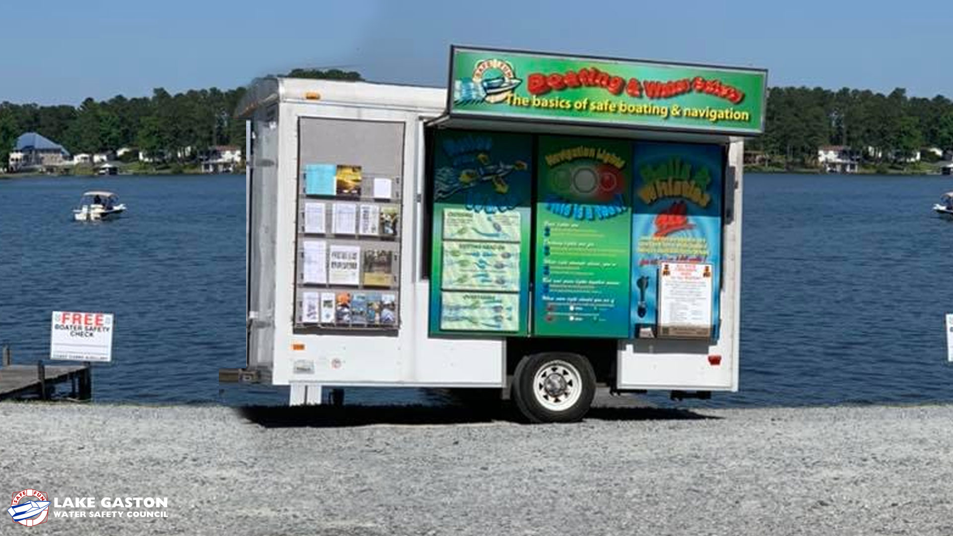
During the general boating season each year, the Lake Gaston Water Safety Council (LGWSC), as a public outreach service, operates a colorful informational Safety Trailer staffed by its members to provide a wide range of informational literature concerning boating laws and regulations (not only Federal but for both North Carolina and Virginia, as well). Additionally, helpful locally generated literature is available to aid residents, guests, visitors, and tourists about Lake Gaston NC & VA waters and the immediate surrounding area. Beyond the literature, verbal information and advice from the trailer staff is always fully available.
The LGWSC Safety Trailer is strategically stationed at (and rotated among) various venues in the Lake Gaston area so that the variety of people and lifestyles have access to the trailer's offerings. The concerns of area residents can be very different from the concerns of area visitors staying at one of the campgrounds (many residents became introduced to the area through campground stays) or tourists who may only be in the area for a day or two (some enjoy their visit so much that they return for longer stays at a campground or, even as a vacation home resident or full-time homeowner). Wake-boarders, water-skiers, bass fishermen, kayakers-and-canoeists (and SUP folks, too), sailboat folks - the Safety Trailer has info and/or contact information for them, too. As well, vessel operating rules vary markedly in certain aspects between Virginia, North Carolina, and Federal laws and regulations. Stop by the Safety Trailer to get information on any/all of the above. If the Safety Trailer information is lacking in some respect, ask the trailer staff member to have the LGWSC Safety Trailer official for assistance in obtaining and returning an answer, or send us a message.